
The image that Artemis II beamed back to Earth on Saturday is by some measure the most expensive photograph yet taken. It shows humanity’s shared home as a speckled blue marble – a reminder of our fragile inheritance. “Trust us, you look amazing. You look beautiful... We’re all one people,” astronaut Victor Glover said to Nasa ground control at the weekend.
Yet as those pixels arrived in Houston, other views of Earth from space were being blacked out by order of the US government.
On Saturday, the commercial satellite imaging company Planet Labs announced in an email to its customers that it would be complying with an official request to censor its imagery of Iran and the wider “conflict region” in the Middle East.
The request came only a few days before Donald Trump threatened he would bomb power plants and bridges in Iran if the regime refused to strike a deal.
“A whole civilization will die tonight, never to be brought back again,” he wrote on Truth Social on Tuesday afternoon. The deliberate targeting of civilian infrastructure is a war crime under the Geneva Conventions.
Hours later, Trump backed down, announcing that Tehran had agreed to a two-week ceasefire. Iranian officials said they would temporarily reopen the Strait of Hormuz if US and Israeli attacks stopped completely. At the time of publication, however, the satellite blackout remains in place. Planet Labs did not respond to requests for comment.
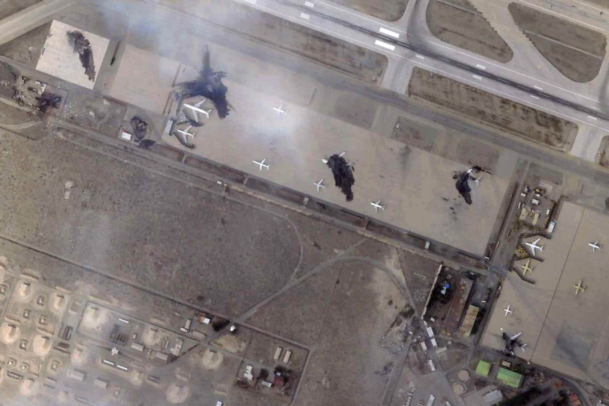
Planet Labs is one of the largest providers of high-resolution satellite imagery. It’s Nato’s eye in the sky and has contracts with several defence intelligence agencies. The firm’s online monitoring tools have also been crucial for journalists reporting on Iran, where the internet has been shut down for more than five weeks.
Various media outlets used them to corroborate the American bombing of a girls’ school in Minab on 28 February, which killed at least 175 people, most of them children. “Open source is not the place to determine what did or did not happen,” US defence secretary Pete Hegseth said in reference to that reporting after the strike.
These are not the first US government restrictions on commercial satellite imagery, though they are the most severe.
On 6 March, Planet Labs complied with an order to implement a 96-hour delay on the release of satellite imagery from the war zone. Days later, it extended that delay to two weeks. “Planet has decided to take additional, proactive measures to ensure our imagery is not tactically leveraged by adversarial actors to target allied and Nato-partner personnel and civilians,” the company said in a statement.
For decades, US federal law has limited the resolution of satellite imagery of Israel and the occupied Palestinian territories. The Kyl–Bingaman amendment to the 1997 National Defense Authorization Act – so named for the two former senators who drafted it – restricted publicly released satellite imagery of the region to 2 metres per pixel. That’s just sharp enough to make out the blurred contours of a car.
The government struggled to maintain these restrictions in the face of rapid technological change. In 2020, under pressure from tech firms, it lowered them to 0.4m – though that’s still only half the resolution at which companies like Planet Labs and Google Earth beam us images of the rest of the world.
The Israeli army was unhappy with the change. “We would always prefer to be photographed at the lowest resolution possible,” retired brigadier general Amnon Harari, head of Israel’s space programs, said at the time. “It's always preferable to be seen blurred, rather than precisely.”
That hasn’t stopped Planet Lab’s images of Gaza being entered as evidence in the genocide case against Israel at the International Court of Justice. The scale of destruction is so total that even abstracted at low resolution, the effects of Israel’s onslaught are plainly evident.
Specific cases, however, can be more difficult to investigate. Eyal Weizman, founder and director of the Forensic Architecture research agency, describes such artificial limits as “the threshold of detectability”.
In his 2017 book Forensic Architecture, he notes that such a low resolution bypasses “risks of privacy infringement when recording people in public places, much in the same way that Google Street View blurs the faces of people or car license plates.” But it also can impede the investigation of drone strikes, because “a hole in a roof – the signature of a drone strike, often no wider than 30 centimetres in diameter – would appear as nothing more than a slight colour variation, a single darker pixel, perhaps”.
“The difference in resolution demonstrates the imbalance of power,” Weizman writes. “While the human body is the object to which drone optics are calibrated, identification of it is the very thing that publicly available satellite images are designed to mask.”
Roughly 200,000km separate the panoramic images of Earth taken from Artemis II and the satellite close-ups now withheld by US decree. The gap between the ways we understand them can seem just as wide. In this case, that may be by design. While a Nasa mission has taken the highest-resolution image of our planet, the US government is now preventing people around the world from seeing Earth at close range. It’s difficult to make sense of geopolitical events from such a distance – and harder still to collect evidence of war crimes.
Photograph by Planet Labs PBC via AP
Newsletters
Choose the newsletters you want to receive
View more
For information about how The Observer protects your data, read our Privacy Policy